Austin, Texas · 30.29° N · July, 3:00 PM
Walk-Free
See how hot every street feels at the hour you walk it, then take the shady way there.
Heat-aware walking for campuses and cities, built for the Meta Global AI Developer Hackathon (Indie track). Meta’s Muse Spark plans the walk in your own language; the map works without an account.
Walk-Free in numbers
6
campuses ready to open: UT Austin, UC Berkeley, Michigan, UCLA, Stanford and Arizona State
10,000+
buildings, each casting a modelled shadow for the hour you pick
900+ km
of walking paths, coloured from full shade to full sun
6
route types: quickest, more shade, scenic, cool stops, step-free, lit at night
Below is a small district drawn for this page, run through the same steps as the app: sun position for a July day in Austin, building and tree shadows projected from it, and every path sampled as shaded or in sun. Scroll to move the clock.
Same street, every hour.
Afternoon, the hottest stretch. Shade survives under Cedar Lane's trees and in thin strips beside tall buildings.
In shade In direct sunSun 69° up, from the WSW
Trade a minute for the shade.
Across the six campuses on a July afternoon, shade routes avoid 13–25% of the sun for 4–7% more walking. The sun-aversion slider (1 to 6, default 3) sets how many metres of shade one metre of sun is worth.
From A (Quarry Road) to B (Lantern Row) at 3 PM. The highlighted walk is drawn in full; the other is dotted.
At 3, a metre in the sun counts as 3 metres in shade. The route leaves the avenue for tree-lined Bluff Walk and Cedar Lane.
Quickest
18 min
- Distance
- 1.41 km
- In shade
- 11%
- In sun
- 16 min
- Feels like
- ~116 °F
More shade (highlighted)
19 min
- Distance
- 1.48 km
- In shade
- 81%
- In sun
- 4 min
- Feels like
- ~108 °F
78% less sun
78% less sun for 5% more walking.
Six kinds of walk
Quickest
The shortest walk, whatever the sun.
More shade
Weighted by the sun-aversion slider.
Scenic
Cool stops
Through air-conditioned libraries and unions.
Step-free
Never takes mapped stairs or slopes over 8%.
Lit at night
Keeps to lit streets after dark.
Plant a row, watch it cool.
The design studio lines a street with trees and shows shade share and feels-like before and after, for the street and the whole area. One button writes it up as a one-page proposal; another downloads the street heat as CSV for planners.
- Shade on Long Avenue13%
- Feels like on Long Avenue
- 116°F
- Shade across the district42.7%
Trees no one mapped.
Volunteers map street trees, not back gardens or creek banks. Walk-Free reads Meta and WRI’s 1 m Canopy Height Maps (v2, built with DINOv3) on the server, by byte range from cloud-optimised GeoTIFFs. A 9 m cell becomes a crown when at least 45% of it stands 3 m or taller.
At UC Berkeley that turns about 216 mapped trees into roughly 11,100. Drag the divider to compare.
4,375trees mapped in OpenStreetMap across the six campuses
+33,136inferred crowns in view (of 62,748), from the canopy-height maps
Measured, then walked.
Every number in the app comes from open data, recomputed for the hour you choose. Feels-like is labelled as an estimate, not a measurement. If one weather source is down, the next one answers; if the walking graph has a gap, quick walks fall back to OSRM, then Valhalla, then a labelled straight-line estimate.
Shadiest way from the library to the union at 3?
- find_places
- plan_route
- best_time_to_leave
- compare_walks
The shade route on the map takes a minute longer and keeps you out of the sun for most of it. Leaving at 5 would feel cooler still.
Itinerary for one walk
The ground
- Streets, paths, buildings, trees from OpenStreetMap
- Overpass
- Tree crowns from 1 m canopy-height maps
- Meta + WRI
The sky
- Temperature, humidity, sunlight in W/m², UV
- Open-Meteo
- Heat and air-quality alerts, HeatRisk
- NWS
- Air quality (US AQI)
- CAMS
The walk
- Sun position for the chosen hour
- any hour
- Shade ray-traced against buildings and crowns
- per path
- Feels-like: heat index, plus up to 8 °C in sun
- estimate
- Shade-weighted shortest path
- 6 types
Result: the walk, coloured by heat, with minutes in sun
Seven invented cities, seven weathers.
Describe any city and the assistant plans districts, sixteen kinds of landmark, street names, climate and sky. A deterministic builder makes it walkable in under 200 ms, with walkers who thin out at night and drift toward shade in the heat.
Noir Harbor
Fictional cityRain, 9 PM
Black towers, gold windows and rain that never lets up.
Skyline Prime
Fictional cityClear, glare
Chrome towers and wide boulevards in hard noon light.
Velocity Bay
Fictional cityBay breeze
Long straight avenues off the bay, where the wind leaves streaks.
Aurora Realm
Fictional cityAurora
A golden citadel at the edge of the northern sky.
Neon District
Fictional cityNight, neon
The night never ends under a thousand signs.
Dune Reach
Fictional cityDesert, 3 PM
The open boulevards bake; the old quarter's lanes keep the shade.
Quickest route 0% shade. Shade route 68%.
Verdant Canopy
Fictional cityUnder canopy
A city that grew a forest over every street.
87% of walking in shade.
Or describe your own.
“a rain-soaked noir city from a 90s cartoon”
The assistant plans districts, landmarks, street names, climate and sky; a deterministic builder turns that plan into a walkable city.
GeneratedRavenmoor
930 buildings, built in 0.2 s
From the real app.
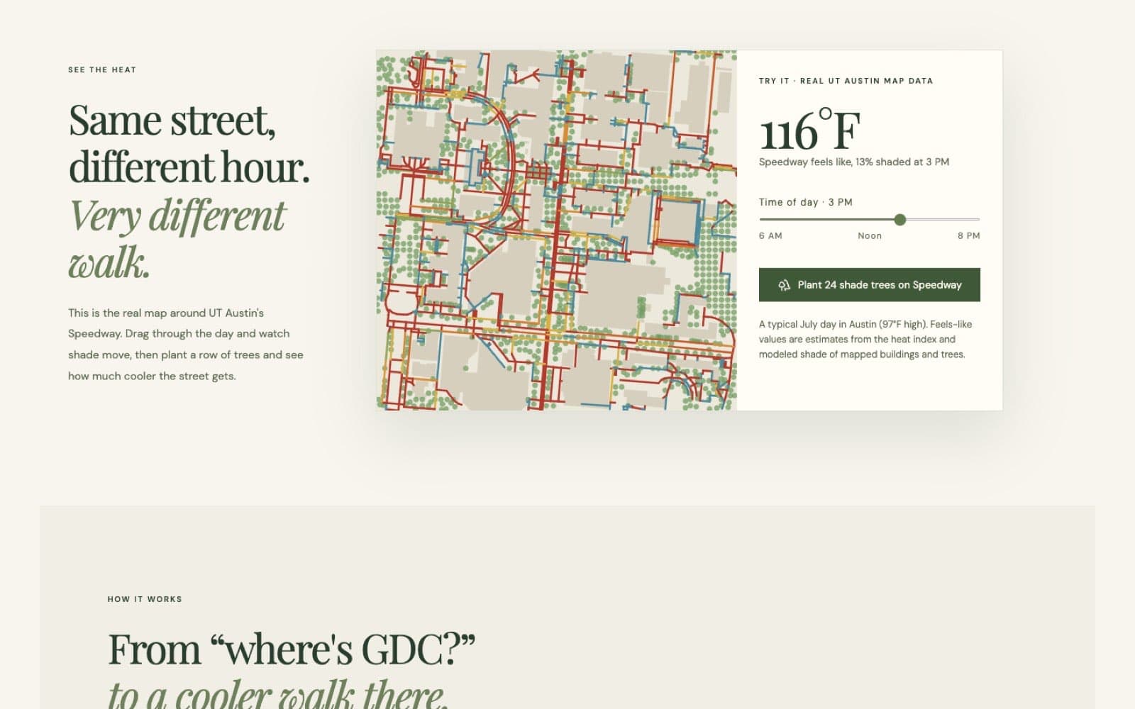
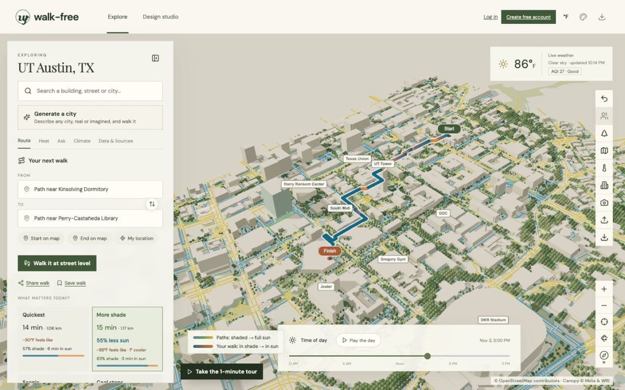
Heat on the groundUT AustinPaths coloured by feels-like at the chosen hour 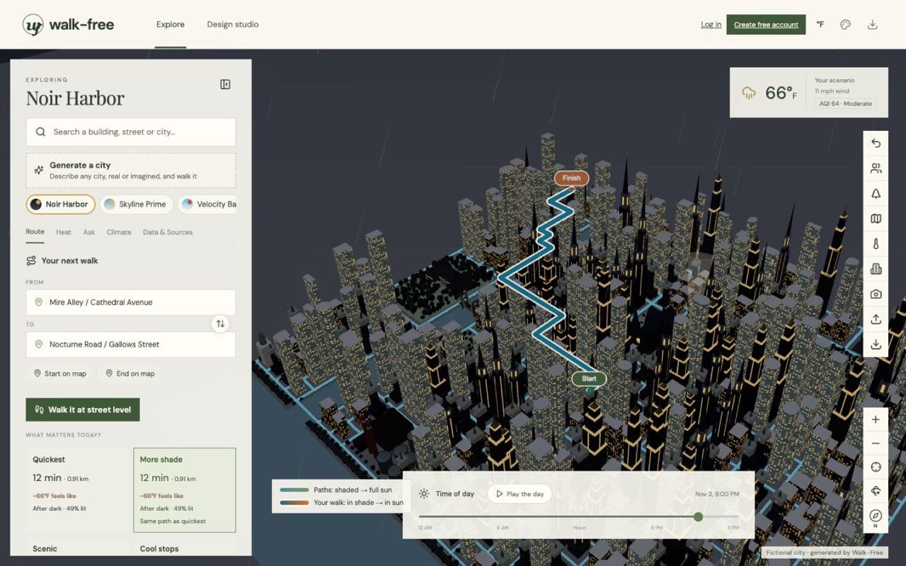
A generated cityNoir HarborRain layer at 9 PM 
The first screenLandingHemphill Park, 117 °F in full sun at 3 PM in July 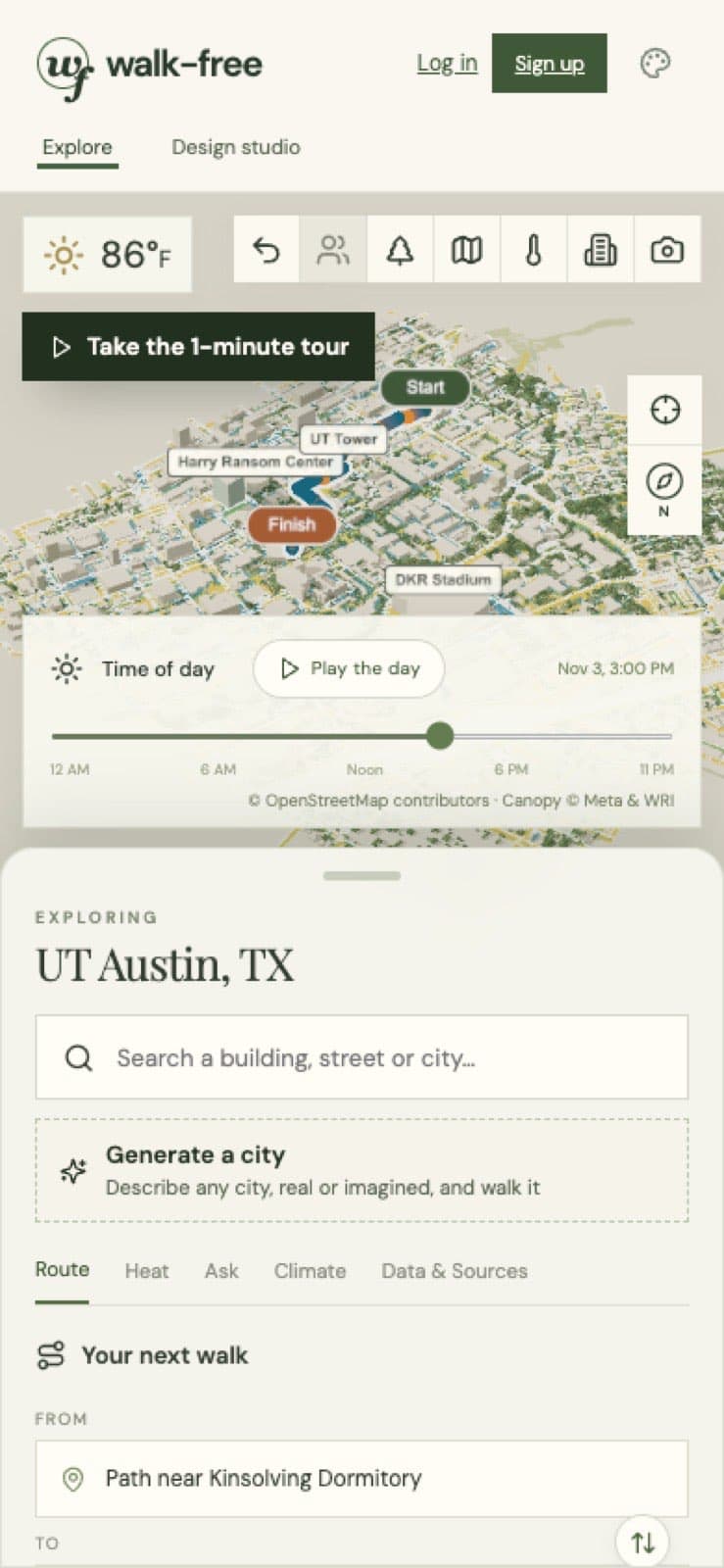
Bottom-sheet layoutPhoneInstallable PWA, works offline
What it’s made of
- React 19
- TypeScript
- Vite
- three.js / React Three Fiber
- MapLibre
- Express 5 on Vercel
- Neon Postgres + Neon Auth
- Capacitor
- Meta Muse Spark
Four interface styles: Editorial, Night, Sunlight (high contrast for glare) and Blueprint, in °F or °C. The walking view follows you on a flat north-up map with next-turn banners like “In shade for 120 m”, and can speak the guidance.
Installable as an offline PWA, with Capacitor projects for iOS and Android (not yet tested on devices). About sixty test files cover the model, routing and tools.
Take the shady side.
The guided demo opens UT Austin and walks through a shade route in about a minute. No account needed.